Kedar Kantha Trek
Kedarkantha is an easy trek that is gorgeous in summer and considered one of India’s most scenic snow treks. The state of India is also known as Dev Bhoomi (Uttarakhand). Sankari Goan is a resident of the Uttarkashi district. Kedarkantha Mountain is above this village. Its height reach is 12500 ft means 3800 mtr. There is a Wildlife Sanctuary there was converted into Govind Pashu Vihar National Park by the Uttarakhand Government in 1955. It has a starting point. Dehradun City is also known as the City of Love. This journey starts from here. Kempty Falls passes through Mussoorie Pahadon ki Rani means (Queens of Hills) and enters the Sankari Goan. In winter, many tourists come here for trekking—the next step from starting Sankri. Juba ka Talab reaches. There is a lovely pond.
Trip Highlights Kedarkantha is an easy trek that is gorgeous in summer and considered one of India's most scenic snow treks. Kempty Falls passes through Mussoorie Pahadon ki Rani means (Queens of Hills) and enters the Sankari Goan. In winter, many tourists come here for trekking—the next step from starting Sankri.
Day 01: Reach Kotgaon (6,800 ft); 10-11 hours drive from Dehradun
Leave Dehradun by 6:30 am and reach Kotgaon at 5:30pm. is a small pretty village. A few dhabas and some shops make Kotgaon. Stay at the GMVN guest house slightly up the road. Most trekkers get to Kotgaon in the evening, which is a good time to lookout for the sun setting on the Greater Himalayan mountain ranges. The peaks of Swargarohini shimmer in the evening sun, standing tall over the ridges beyond Kotgaon.
Day 02: Kotgaon (6,800 ft) to Khujey (9,400 ft); 5 hours
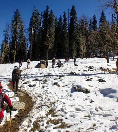
Take the tarred road out of Sankri until you come to an extension of the Sankri village called Sol. Once you cross the village, the road takes a wide curve. Around 7-8 minutes later, look for a trail to your right that climbs sharply – it is next to a stream. This is the trail that leads to Kedarkantha. If in doubt, wait for a local to pass by and ask for directions. The trail gets into the pine forest and starts to climb sharply until you reach a ridge ten minutes later. On the ridge, the trail evens out and widens for almost the rest of the day. An hour later, look for a small wooden bridge on your right. A hut that belongs to a shepherd is visible beyond the bridge, about 40-50 metres higher on the trail. You are a quarter of your way to Juda-ka-Talab here. After a while, the stream that you have been hearing catches up with you. This is your last water point, so fill up your bottles to last until Juda-ka-Talab, another thousand feet higher and 2½ hours further. Don’t take the trail that goes over the bridge, but continue on the trail that runs to your left – it is clearly visible and forks clearly at the stream. Half an hour later, in a large grove of Maple trees, look for a large trunk of a tree fallen on the ground. Beyond the tree, a dark forest beckons you mysteriously from the southern edge of the clearing. At 8,100 feet, you are half way into your trek to Juda-Ka-Talab here. Carry on the trail through the clearing to re-enter the sparse pine and maple forest on its northern edge. Through a series of switchbacks, the trail climbs rapidly through dense oaks finally emerging out in the open over a rising mound to greet you with the spectacular camp site of Juda-Ka-Talab. Juda-Ka-Talab is almost too perfect in its setting as a campsite. On your left is the large lake that was once two lakes but now conjoined as one, and on your right is the thick edge of an oak and pine forest. The forest is so dense that light hardly seeps through it. The campsite is a series of gentle undulating mounds that form the clearing and campsite of Juda-Ka-Talab. High above, on your left, is the ridge line through which the afternoon light filters in. The area is entirely in shadows of some of the densest pine forest you will ever see.
Day 03: Khujey (9,400 ft) to Bhuja Dhadi (10,800 ft); 2 hours
The trail out of Juda Ka Talab is clearly visible and straight forward. The trail rises to a ridge at the edge of the lake. At the ridge, take a sharp left turn and dive into the dense pine forest climbing higher.The trail veers further left sticking to the slope directly above Juda Ka Talab, though the lake is not visible. Climbing swiftly, the trail pops out at a ridge in another half hour, gaining about 800 feet over Juda Ka Talab. The ridge flattens out with oaks mainly as company. Continue walking on the ridge to the edge of the meadow and start another sharp climb through the oaks. Half an hour later, the ridge opens out to yet another open meadow on your right with a solitary shepherd’s hut (Hut Point). The setting is strikingly beautiful and calls for a break from the trek. You have less than a thousand feet to climb from here to the Kedarkantha base. A short climb later, again in the shades of the oaks, the trail opens out to a large clearing on the northern edge of which is another shepherd’s hut. Look behind you for your first awe inspiring 180 degree view of snow ranges surrounding the Kedarkantha summit. The trail switches direction moving in a northerly direction under the dry oak trees. Usually over snow, the trail climbs gently in two stages to another clearing. You have arrived at the Kedarkantha base camp site, marked by another dilapidated shepherd’s hut. White peaks stretch from your left to your right forming a wide arc. Bandarpoonch, Swargarohini, Kala Nag and Ranglana stand out from the scores others.
Day 04: Bhuja Dhadi (10,800 ft) to Kedarkantha summit (12,500 ft) and then on to Munaila/ Bhuja Dhadi; 7 hours
Sunrise from the Kedarkantha Base is something worth getting out of your sleeping bags early for. The Kedarkantha peak is clearly visible from the KK Base. There are many trails that go to the top. The best route is to catch the northern ridge of the Kedarkantha summit, climb up in a series of switchbacks to reach the Kedarkantha summit. It takes an hour and half to climb the summit from the Kedarkantha base campsite. The Kedarkantha summit is marked by a square arrangement of stones with a Trishul that points to the sky. Towering over the rest of the region, the summit gives you a 360 degree view of the mighty snow clad ranges of Uttarakhand. The Gangotri and the Yamunotri ranges are clearly visible from the summit, as are the Chanshil Pass and Kinnaur Kailash ranges. Getting down from the summit, take an alternate route down to your camp following the southern ridge of Kedarkantha. It is a straight forward ridge descent to the oak forest below. Note: Depending on the amount of snow, many trekkers prefer to climb Kedarkantha from the southern ridge and descend by the northern side. The snow is less on the southern ridge and makes climbing easier. Both routes take approximately the same time, so choose a route depending on the snow. Get back to your Kedarkantha base camp site by noon and not later than that. A quick lunch later, wrap your camp and begin your descent to Hargaon. The trail is spectacular as it ascends and descends through oaks, pines and frozen streams. It moves through small clearings every half hour or so. The clearings are a unique feature to the Kedarkantha trail and a rarity in the Indian Himalayas. Some of the clearings are marked by huts of the shepherds. Continue your descent until you come to the wide clearing of Hut Point. Instead of taking the ridge down from here, descend to the meadow that runs below you. At the end of the meadow, move to your right, cross the open stream and take the trail that moves down the slope but avoids the ridge that runs parallel above. A while later, get to the cluster of four shepherds’ huts that you saw on your way up from the trail on the ridge. Continue past the cluster of four huts and re-enter the deep dark pine forest that engulfs the trail as it moves further and further away from the ridge. The trail gets exquisitely beautiful as it winds its way down an enchanted forest of pines to reach the Hargaon clearing in an hour and half’s time.
Day 05: Munaila to Sankri/ Kotgaon (6,800 ft); 5 hours
The trail to Sankri is clearly marked by stones and its well-paved nature. Descend through the pines and in a series of switchbacks, come to a stream to your left. This is a good spot to fill water. The trail evens out and gradually descends through the pine forest to come to a ridge. From the ridge, catch a view of the vast open Har-ki-dun valley. Slightly below, as you descend, an apple orchard mixed with potato and cauliflower farms greet you. Huts that belong to local farmers line up on the right, standing out in the skyline. There are numerous trails to Sankri, but the main one is the five foot-broad trail that everyone uses. Resume your descent until you get to the pine forest a couple of hundred feet above Sankri. The trail forks multiple times here, with each heading to a different part of Sankri. Wait for a local to show you the direction to GMVN, which is a sharp detour from the main trail to the left. Descend down to GMVN in ten minutes to culminate a grand trek in the Uttarakhand Himalayas.
Day 06: Drive to Dehradun; 10-11 hours.
Drive back to Dehradun through lovely pine forests and beside the Tons river. It’s a long 8 hour drive. Try and get the window seat on the right side to get a good view! Stop for lunch somewhere near Kempty Falls. You’ll reach Dehradun by 8 pm.
Our Satisfied Guests says
We love to tell our successful far far away, behind the word mountains, far from the countries .
" Thanks to Discover Garhwal Himalaya for the best vacation I've had in years.
We loved the Valley of flower trek. I would definitely do a trek again. I was impressed at how well organized everything was and our Camp and meals were fantastic.
The trip was great and we would recommend it to others. The accommodations were truly incredible. We had a fantastic time. The places they picked for us to stop at were perfect.
Sign Up for a Newsletter
Sign up for our mailing list to get latest updates and offers.